
Make a donation
Gear up for your next adventure:
As an Amazon Associate, this site earns from qualifying purchases at no extra cost to you.
Moitzfeld topographic map
Click on the map to display elevation.
Make a donation
Gear up for your next adventure:
As an Amazon Associate, this site earns from qualifying purchases at no extra cost to you.
Moitzfeld
Die Topographia Ducatus Montani des Erich Philipp Ploennies, Blatt Amt Porz, belegt, dass der Wohnplatz 1715 als Freyerhof kategorisiert wurde und mit Motzfeld bezeichnet wurde. Carl Friedrich von Wiebeking benennt die Hofschaft auf seiner Charte des Herzogthums Berg 1789 als Mosfeld. Aus ihr geht hervor, dass Moitzfeld zu dieser Zeit Teil der Honschaft Bensberg im Kirchspiel Bensberg war.
Make a donation
Gear up for your next adventure:
As an Amazon Associate, this site earns from qualifying purchases at no extra cost to you.
About this map
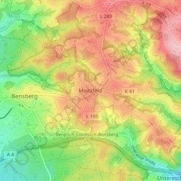
Name: Moitzfeld topographic map, elevation, terrain.
Average elevation: 597 ft
Minimum elevation: 315 ft
Maximum elevation: 873 ft
Make a donation
Gear up for your next adventure:
As an Amazon Associate, this site earns from qualifying purchases at no extra cost to you.
Other topographic maps
Click on a map to view its topography, its elevation and its terrain.
Kradepohlsmühle
Deutschland > Nordrhein-Westfalen > Rheinisch-Bergischer Kreis > Bergisch Gladbach > Kradepohlsmühle
Average elevation: 262 ft
51427
Deutschland > Nordrhein-Westfalen > Rheinisch-Bergischer Kreis > Bergisch Gladbach
Average elevation: 410 ft