
Thank you for supporting this site ❤️
Make a donation
Make a donation
Gear up for your next adventure:
As an Amazon Associate, this site earns from qualifying purchases at no extra cost to you.
Les Trois-Bassins topographic map
Click on the map to display elevation.
Thank you for supporting this site ❤️
Make a donation
Make a donation
Gear up for your next adventure:
As an Amazon Associate, this site earns from qualifying purchases at no extra cost to you.
About this map
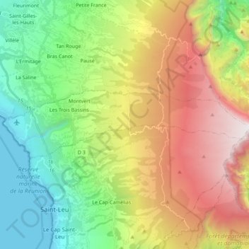
Name: Les Trois-Bassins topographic map, elevation, terrain.
Location: Les Trois-Bassins, Saint-Paul, La Reunión, 97426, Francia (-21.13563 55.25285 -21.09195 55.42257)
Average elevation: 3,681 ft
Minimum elevation: 0 ft
Maximum elevation: 9,393 ft
Thank you for supporting this site ❤️
Make a donation
Make a donation
Gear up for your next adventure:
As an Amazon Associate, this site earns from qualifying purchases at no extra cost to you.
Other topographic maps
Click on a map to view its topography, its elevation and its terrain.