Geolocate

Bang Bala topographic map

Interactive map

Click on the map to display elevation.

About this map

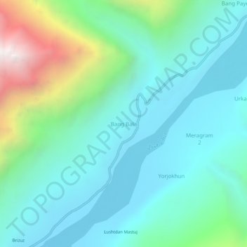
Name: Bang Bala topographic map, elevation, terrain.

Location: Bang Bala, Upper Chitral District, Former Chitrāl District, Malakand Division, Khyber Pakhtunkhwa, Pakistan (36.50524 72.74480 36.54524 72.78480)

Average elevation: 9,590 ft

Minimum elevation: 8,261 ft

Maximum elevation: 14,265 ft

Other topographic maps

Click on a map to view its topography, its elevation and its terrain.

Madak Lusht

Pakistan > Khyber Pakhtunkhwa > Former Chitrāl District

Madak Lusht, Lower Chitral District, Former Chitrāl District, Malakand Division, Khyber Pakhtunkhwa, Pakistan

Average elevation: 9,862 ft

Damshogoor Drosh

Pakistan > Khyber Pakhtunkhwa > Former Chitrāl District

Damshogoor Drosh, Lower Chitral District, Former Chitrāl District, Malakand Division, Khyber Pakhtunkhwa, 17220, Pakistan

Average elevation: 5,079 ft

Lower Chitral District

Pakistan > Khyber Pakhtunkhwa > Former Chitrāl District

Lower Chitral District, Former Chitrāl District, Malakand Division, Khyber Pakhtunkhwa, 17220, Pakistan

Average elevation: 12,090 ft

Drosh

Pakistan > Khyber Pakhtunkhwa > Former Chitrāl District > Drosh

Drosh, Lower Chitral District, Former Chitrāl District, Malakand Division, Khyber Pakhtunkhwa, Pakistan

Average elevation: 6,073 ft

Former Chitrāl District

Pakistan > Khyber Pakhtunkhwa > Former Chitrāl District

Former Chitrāl District, Khyber Pakhtunkhwa, Pakistan

Average elevation: 12,234 ft

Tirich Mir

Pakistan > Khyber Pakhtunkhwa > Former Chitrāl District

Tirich Mir, Former Chitrāl District, Khyber Pakhtunkhwa, Pakistan

Average elevation: 22,316 ft