Geolocate

Prescott topographic map

Click on the map to display elevation.

About this map

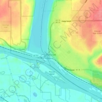
Name: Prescott topographic map, elevation, terrain.

Location: Prescott, Pierce County, Wisconsin, United States (44.73232 -92.80772 44.76845 -92.76136)

Average elevation: 761 ft

Minimum elevation: 656 ft

Maximum elevation: 935 ft

Pierce County trails, hiking, mountain biking, running and outdoor activities

Other topographic maps

Click on a map to view its topography, its elevation and its terrain.

Lake George

United States > Wisconsin > Pierce County > River Falls

Average elevation: 906 ft

Gear up for your next adventure:

🛠️Backpacking Tool Kit - Essential toolkit for outdoor repairs
🚑Emergency Bivvies - Heat-reflective sleeping bags for survival situations
🥾Men's Hiking Boots - Durable, waterproof footwear for rugged terrain and steep inclines
📱Solar Portable Charger - Solar power bank for charging devices off‑grid
🪶Thermal Camp Blanket - Extra warmth for cold nights

As an Amazon Associate, this site earns from qualifying purchases at no extra cost to you.