Geolocate

Caripito topographic map

Click on the map to display elevation.

About this map
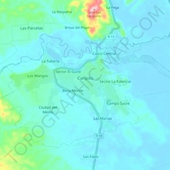
Name: Caripito topographic map, elevation, terrain.

Location: Caripito, Parroquia Caripito, Municipio Bolívar, Estado Monagas, 6211, Venezuela (10.07355 -63.15025 10.14335 -63.05452)

Average elevation: 118 ft

Minimum elevation: 3 ft

Maximum elevation: 1,004 ft

Other topographic maps

Click on a map to view its topography, its elevation and its terrain.

Caripito

Venezuela > Estado Monagas > Municipio Bolívar > Caripito

Average elevation: 427 ft

Azagua

Venezuela > Estado Monagas > Municipio Bolívar

Average elevation: 135 ft

Azagua

Venezuela > Estado Monagas > Municipio Bolívar

Average elevation: 135 ft

Gear up for your next adventure:

🪑Ultralight Camp Chairs - Portable seating for resting after a long day of mapping
🗺️Topographic Maps - Detailed topo maps for hiking, exploring and outdoor navigation
🥾Women's Hiking Boots - Top-rated trail boots with ankle support and superior grip
🧢Sun Protection Hats - Wide-brimmed and UPF-rated hats for high-altitude sun safety
🥄Camping Utensil Set - Lightweight utensils for outdoor meals

As an Amazon Associate, this site earns from qualifying purchases at no extra cost to you.