Geolocate

Alpine topographic map

Click on the map to display elevation.

About this map

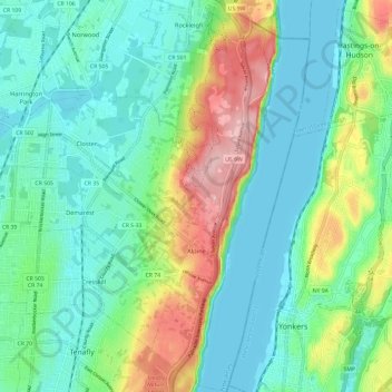
Name: Alpine topographic map, elevation, terrain.

Location: Alpine, Bergen County, New Jersey, 07620, United States (40.91612 -73.94496 41.00600 -73.89363)

Average elevation: 157 ft

Minimum elevation: 0 ft

Maximum elevation: 564 ft

Bergen County trails, hiking, mountain biking, running and outdoor activities

Other topographic maps

Click on a map to view its topography, its elevation and its terrain.

Ridgewood

United States > New Jersey > Bergen County

Average elevation: 184 ft

Darlington

United States > New Jersey > Bergen County > Mahwah

Average elevation: 423 ft

Drag Hill

United States > New Jersey > Bergen County > Mahwah

Average elevation: 827 ft

Stag Hill

United States > New Jersey > Bergen County > Mahwah

Average elevation: 669 ft

Green Hill

United States > New Jersey > Bergen County > Mahwah

Average elevation: 574 ft

Fardale

United States > New Jersey > Bergen County > Mahwah

Average elevation: 407 ft

Cragmere

United States > New Jersey > Bergen County > Mahwah

Average elevation: 446 ft

Teterboro

United States > New Jersey > Bergen County > Teterboro

Average elevation: 39 ft

Westwood

United States > New Jersey > Bergen County > Westwood > Westwood

Average elevation: 102 ft

Glen Rock

United States > New Jersey > Bergen County > Glen Rock > Glen Rock

Average elevation: 171 ft

Hillsdale

United States > New Jersey > Bergen County > Hillsdale > Hillsdale

Average elevation: 131 ft

Gear up for your next adventure:

🔭Stargazing Telescopes - Perfect for camping in low-light pollution areas shown on maps
📚USA Hiking Guide Books - Top trail guides and map books
🎒Waterproof Dry Bags - Keep your electronics and maps dry inside your pack
🌎3D Topographic Globes - Raised relief globes for a tactile understanding of geography
🔥Camping Stove - Portable stove for camping and backcountry cooking

As an Amazon Associate, this site earns from qualifying purchases at no extra cost to you.