
Chiquilistlan topographic map
Interactive map
Click on the map to display elevation.
About this map
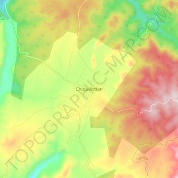
Name: Chiquilistlan topographic map, elevation, terrain.
Location: Chiquilistlan, Chiquilistlán, Jalisco, 48640, México (20.04944 -103.90220 20.12944 -103.82220)
Average elevation: 5,682 ft
Minimum elevation: 4,797 ft
Maximum elevation: 6,591 ft
Other topographic maps
Click on a map to view its topography, its elevation and its terrain.
Chiquilistlán
México > Jalisco > Chiquilistlán
Chiquilistlán, Jalisco, México
Average elevation: 5,732 ft