
Chiquilistlán topographic map
Interactive map
Click on the map to display elevation.
About this map
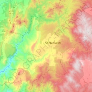
Name: Chiquilistlán topographic map, elevation, terrain.
Location: Chiquilistlán, Jalisco, México (19.95829 -103.98834 20.20179 -103.74642)
Average elevation: 5,732 ft
Minimum elevation: 3,120 ft
Maximum elevation: 8,573 ft
Other topographic maps
Click on a map to view its topography, its elevation and its terrain.
Chiquilistlan
México > Jalisco > Chiquilistlán
Chiquilistlan, Chiquilistlán, Jalisco, 48640, México
Average elevation: 5,682 ft