
Make a donation
Gear up for your next adventure:
As an Amazon Associate, this site earns from qualifying purchases at no extra cost to you.
Västerås topographic map
Click on the map to display elevation.
Make a donation
Gear up for your next adventure:
As an Amazon Associate, this site earns from qualifying purchases at no extra cost to you.
Västerås
Västerås is predominantly known as an industrial city, but also a retailing and logistics city. The city wants to distinguish itself as Västerås – Mälarstaden, meaning "Västerås—the city by Lake Mälaren", in order to attract tourists and new residents, as well as students to the local university, Mälardalen University (approximately 16,000 students enrolled in Västerås and in nearby Eskilstuna). To this effect, the city has started using a special logo as branding in some official contexts, partially replacing its coat of arms, as well as rebuilding several old harbor areas to make them more attractive to live in. Västerås has the largest lakeside commercial and recreational port in Scandinavia on Lake Mälaren. The lake has many islands, and there are tourist boats that go out to them daily in the summer. The city also has a skyscraper colloquially nicknamed "Skrapan" (English: The Scraper), which features Sweden's highest-elevation cocktail bar, the Sky Bar, located on the 24th floor. Until 2017, Västerås hosted Power Big Meet, an annual event for owners and enthusiasts of classic American cars. The event moved to Lidköping in 2017 after organizers decided that it had outgrown all the available facilities in Västerås. Long-time Power Big Meet collaborator Klas Brink instead arranged the competing Västerås Summer Meet at the same location as Power Big Meet had been arranged for years.
Make a donation
Gear up for your next adventure:
As an Amazon Associate, this site earns from qualifying purchases at no extra cost to you.
About this map
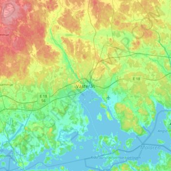
Name: Västerås topographic map, elevation, terrain.
Location: Västerås, Västerås kommun, Västmanland County, 721 01, Sweden (59.45110 16.38637 59.77110 16.70637)
Average elevation: 92 ft
Minimum elevation: -13 ft
Maximum elevation: 335 ft
Make a donation
Gear up for your next adventure:
As an Amazon Associate, this site earns from qualifying purchases at no extra cost to you.
Other topographic maps
Click on a map to view its topography, its elevation and its terrain.
Make a donation
Gear up for your next adventure:
As an Amazon Associate, this site earns from qualifying purchases at no extra cost to you.