
Make a donation
Gear up for your next adventure:
As an Amazon Associate, this site earns from qualifying purchases at no extra cost to you.
Römnitz topographic map
Click on the map to display elevation.
Make a donation
Gear up for your next adventure:
As an Amazon Associate, this site earns from qualifying purchases at no extra cost to you.
About this map
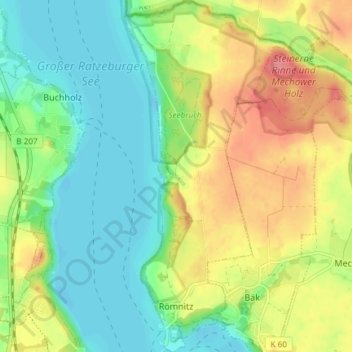
Name: Römnitz topographic map, elevation, terrain.
Average elevation: 92 ft
Minimum elevation: -3 ft
Maximum elevation: 230 ft
Make a donation
Gear up for your next adventure:
As an Amazon Associate, this site earns from qualifying purchases at no extra cost to you.
Other topographic maps
Click on a map to view its topography, its elevation and its terrain.
Rothenhusen
Deutschland > Schleswig-Holstein > Kreis Herzogtum Lauenburg > Groß Sarau
Average elevation: 66 ft
Drüsen
Deutschland > Schleswig-Holstein > Kreis Herzogtum Lauenburg > Lehmrade
Average elevation: 131 ft
Make a donation
Gear up for your next adventure:
As an Amazon Associate, this site earns from qualifying purchases at no extra cost to you.
Dalbekschlucht
Deutschland > Schleswig-Holstein > Kreis Herzogtum Lauenburg > Börnsen
Average elevation: 131 ft