Geolocate

Pineda topographic map

Click on the map to display elevation.

About this map

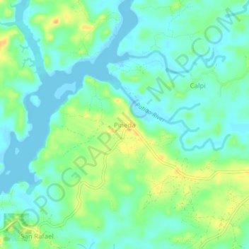
Name: Pineda topographic map, elevation, terrain.

Location: Pineda, Pilar, Sorsogon, Bicol Region, Philippines (12.90618 123.69024 12.94618 123.73024)

Average elevation: 39 ft

Minimum elevation: -3 ft

Maximum elevation: 112 ft

Gear up for your next adventure:

🧣Merino Neck Gaiters - Multi-functional headwear for wind and sun protection
🧥Waterproof Jacket for Hiking - Breathable and rugged rain jacket for outdoor excursions
🚁Photography Drones - Capture stunning aerial views of landforms and topography
🌐World Map Poster - Decorative world maps with topographic info
📦Gear Storage Bags - Organize and protect outdoor equipment

As an Amazon Associate, this site earns from qualifying purchases at no extra cost to you.