
Mammoth topographic map
Click on the map to display elevation.
About this map
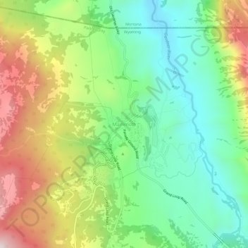
Name: Mammoth topographic map, elevation, terrain.
Location: Mammoth, Park County, Wyoming, United States (44.95663 -110.72072 44.99663 -110.68072)
Average elevation: 6,444 ft
Minimum elevation: 5,610 ft
Maximum elevation: 7,779 ft
Park County trails, hiking, mountain biking, running and outdoor activities
Other topographic maps
Click on a map to view its topography, its elevation and its terrain.
Cody
United States > Wyoming > Park County
Cody's elevation is approximately 5016 ft (1,500 m) above sea level. The main part of the city is split across three levels, separated by about 60 feet (18 m).
Average elevation: 5,108 ft
Cody
United States > Wyoming > Park County
Cody's elevation is approximately 5016 ft (1,500 m) above sea level. The main part of the city is split across three levels, separated by about 60 feet (18 m).
Average elevation: 5,108 ft
Cody
United States > Wyoming > Park County
Cody's elevation is approximately 4,997 feet (1,523 m) above sea level. The main part of the city is split across three levels, separated by about 60 feet (18 m).
Average elevation: 5,108 ft