Geolocate

Omegna topographic map

Click on the map to display elevation.

About this map

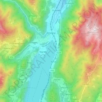
Name: Omegna topographic map, elevation, terrain.

Location: Omegna, Verbano-Cusio-Ossola, Piedmont, Italy (45.82935 8.36461 45.90364 8.45762)

Average elevation: 2,211 ft

Minimum elevation: 794 ft

Maximum elevation: 4,882 ft

Gear up for your next adventure:

🧣Hiking Neck Gaiter - Multi‑use neck protection for outdoor weather
🧢Sun Protection Hats - Wide-brimmed and UPF-rated hats for high-altitude sun safety
🌐World Map Poster - Decorative world maps with topographic info
🚗GPS Dash Cams - Record your scenic drives through mountain passes and canyons
📶Satellite Messenger - Communication device off‑grid

As an Amazon Associate, this site earns from qualifying purchases at no extra cost to you.