
Make a donation
Gear up for your next adventure:
As an Amazon Associate, this site earns from qualifying purchases at no extra cost to you.
Megamendung topographic map
Click on the map to display elevation.
Make a donation
Gear up for your next adventure:
As an Amazon Associate, this site earns from qualifying purchases at no extra cost to you.
Megamendung
Much of the district lies at an elevation of 500-600 metres, which moderates the temperature, and causing contrast to the heat of Greater Jakarta and other adjacent low-lying lands. Though much of the built-up area is not necessarily on rugged terrain, uneven ground is the most common terrain as it stands sandwiched between mountains. The area is also close to Gunung Gede Pangrango National Park, where a portion of the park itself lies within district boundaries.
Make a donation
Gear up for your next adventure:
As an Amazon Associate, this site earns from qualifying purchases at no extra cost to you.
About this map
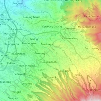
Name: Megamendung topographic map, elevation, terrain.
Location: Megamendung, Bogor, West Java, Java, 16770, Indonesia (-6.72664 106.85290 -6.62500 106.99094)
Average elevation: 2,434 ft
Minimum elevation: 801 ft
Maximum elevation: 6,040 ft
Make a donation
Gear up for your next adventure:
As an Amazon Associate, this site earns from qualifying purchases at no extra cost to you.