
Make a donation
Gear up for your next adventure:
As an Amazon Associate, this site earns from qualifying purchases at no extra cost to you.
Libanus topographic map
Click on the map to display elevation.
Make a donation
Gear up for your next adventure:
As an Amazon Associate, this site earns from qualifying purchases at no extra cost to you.
About this map
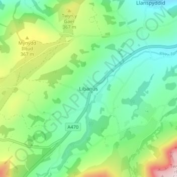
Name: Libanus topographic map, elevation, terrain.
Location: Libanus, Powys, Wales, LD3 8EJ, United Kingdom (51.90402 -3.48362 51.94402 -3.44362)
Average elevation: 892 ft
Minimum elevation: 495 ft
Maximum elevation: 1,824 ft
Make a donation
Gear up for your next adventure:
As an Amazon Associate, this site earns from qualifying purchases at no extra cost to you.
Other topographic maps
Click on a map to view its topography, its elevation and its terrain.
Brecon Beacons National Park
United Kingdom > Wales > Powys
Brecon Beacons National Park, officially named Bannau Brycheiniog National Park (Welsh pronunciation), is a national park in Wales. It is named after the Brecon Beacons (Welsh: Bannau Brycheiniog), the mountain range at its centre. The national park includes the highest mountain in South Wales, Pen y Fan,…
Average elevation: 886 ft