Geolocate
Thank you for supporting this site ❤️Make a donation

Blue Rock topographic map

Click on the map to display elevation.

About this map

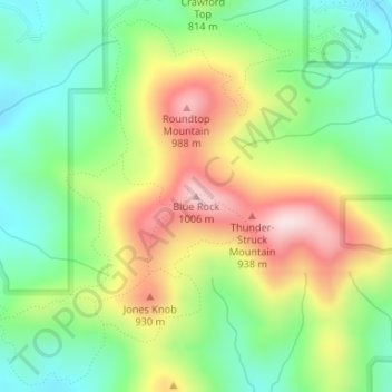
Name: Blue Rock topographic map, elevation, terrain.

Location: Blue Rock, Union County, Georgia, United States (34.88532 -83.89995 34.88542 -83.89985)

Average elevation: 2,559 ft

Minimum elevation: 2,031 ft

Maximum elevation: 3,330 ft

Other topographic maps

Click on a map to view its topography, its elevation and its terrain.

Blairsville

United States > Georgia > Union County

Blairsville, Union County, Georgia, United States

Average elevation: 1,926 ft

Hawk Mountain

United States > Georgia > Union County

Hawk Mountain, Union County, Georgia, United States

Average elevation: 2,992 ft

Vogel State Park

United States > Georgia > Union County

Vogel State Park, Union County, Georgia, United States

Average elevation: 2,749 ft

Suches

United States > Georgia > Union County

Suches, Union County, Georgia, United States

Average elevation: 2,858 ft

Bethlehem

United States > Georgia > Union County

Bethlehem, Union County, Georgia, United States

Average elevation: 1,909 ft

Fort Mountain

United States > Georgia > Union County

Fort Mountain, Union County, Georgia, United States

Average elevation: 2,228 ft

In order to remain free and to keep improving, this site uses cookies created by Google to compile visit statistics and display personalized advertisements.

How is the collected data used?