Geolocate

Tagdangua topographic map

Click on the map to display elevation.

About this map

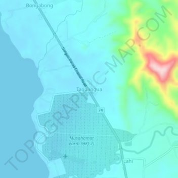
Name: Tagdangua topographic map, elevation, terrain.

Location: Tagdangua, Davao de Oro, Davao Region, Philippines (7.18493 125.86337 7.22493 125.90337)

Average elevation: 118 ft

Minimum elevation: 0 ft

Maximum elevation: 879 ft

Other topographic maps

Click on a map to view its topography, its elevation and its terrain.

Laak

Philippines > Davao de Oro

Average elevation: 554 ft

New Bataan

Philippines > Davao de Oro

Average elevation: 2,457 ft

Gear up for your next adventure:

🌡️Portable Weather Meter - Track weather conditions on the trail
📌Outdoor GPS Map App - Apps and devices for digital topographic navigation
🗻Climbing Gear Basics - Essential gear for beginner climbers
🎒Waterproof Dry Bags - Keep your electronics and maps dry inside your pack
🛡️Insect Repellent - Protection against bugs during outdoor activities

As an Amazon Associate, this site earns from qualifying purchases at no extra cost to you.