
Azuay topographic map
Interactive map
Click on the map to display elevation.
About this map
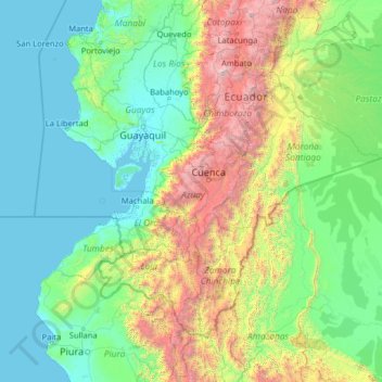
Name: Azuay topographic map, elevation, terrain.
Location: Azuay, Ecuador (-5.61245 -81.79951 -0.49245 -76.67951)
Average elevation: 2,582 ft
Minimum elevation: -7 ft
Maximum elevation: 19,800 ft
Other topographic maps
Click on a map to view its topography, its elevation and its terrain.
Victoria del Portete
Victoria del Portete, Cuenca, Azuay, Ecuador
Average elevation: 9,623 ft
Guagrahuma
Guagrahuma, Sayausí, Cuenca, Azuay, Ecuador
Average elevation: 13,081 ft
Pueblo Viejo
Pueblo Viejo, Sidcay, Cuenca, Azuay, 010115, Ecuador
Average elevation: 8,845 ft
Cerro Verde
Cerro Verde, El Valle, Cuenca, Azuay, 010211, Ecuador
Average elevation: 9,199 ft
Río Tenguel
Ecuador > Azuay > Camilo Ponce Enríquez
Río Tenguel, Camilo Ponce Enríquez, Azuay, Ecuador
Average elevation: 161 ft
San Gerardo
Ecuador > Azuay > San Gerardo
San Gerardo, Girón, Azuay, Ecuador
Average elevation: 9,938 ft