
Make a donation
Gear up for your next adventure:
As an Amazon Associate, this site earns from qualifying purchases at no extra cost to you.
Port Vila topographic map
Click on the map to display elevation.
Make a donation
Gear up for your next adventure:
As an Amazon Associate, this site earns from qualifying purchases at no extra cost to you.
About this map
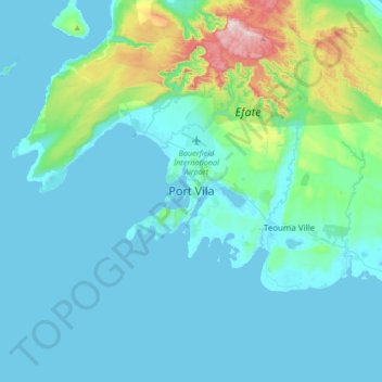
Name: Port Vila topographic map, elevation, terrain.
Location: Port Vila, Shefa Province, Vanuatu (-17.90150 168.15502 -17.58150 168.47502)
Average elevation: 269 ft
Minimum elevation: 0 ft
Maximum elevation: 2,083 ft
Make a donation
Gear up for your next adventure:
As an Amazon Associate, this site earns from qualifying purchases at no extra cost to you.
Other topographic maps
Click on a map to view its topography, its elevation and its terrain.
Tongoa
Vanuatu > Shefa Province > Euta
Tongoa is the largest island of Shepherd Islands archipelago. The island is heavily vegetated and shows geothermal activity. Tongoa is of recent volcanic origin but currently has no currently active volcano. There are numerous volcanic cones on the island and some black sand beaches. The estimated terrain…
Average elevation: 292 ft
Make a donation
Gear up for your next adventure:
As an Amazon Associate, this site earns from qualifying purchases at no extra cost to you.