
Make a donation
Gear up for your next adventure:
As an Amazon Associate, this site earns from qualifying purchases at no extra cost to you.
Batna topographic map
Click on the map to display elevation.
Make a donation
Gear up for your next adventure:
As an Amazon Associate, this site earns from qualifying purchases at no extra cost to you.
Batna
La ville de Batna est considérée historiquement comme étant la « capitale » des Aurès. Située à 1 058 mètres d'altitude, elle est la 5e plus importante ville du pays avec 375 000 habitants et la plus haute agglomération d'Algérie bien qu'elle ait été construite dans une cuvette entourée de montagnes.
Make a donation
Gear up for your next adventure:
As an Amazon Associate, this site earns from qualifying purchases at no extra cost to you.
About this map
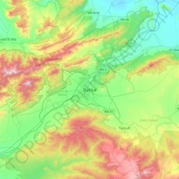
Name: Batna topographic map, elevation, terrain.
Location: Batna, Daïra Batna, Batna, 05000, Algérie (35.39440 6.01675 35.71440 6.33675)
Average elevation: 4,078 ft
Minimum elevation: 2,694 ft
Maximum elevation: 6,778 ft
Make a donation
Gear up for your next adventure:
As an Amazon Associate, this site earns from qualifying purchases at no extra cost to you.