
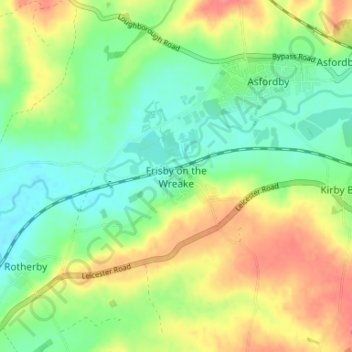
Frisby on the Wreake topographic map
Interactive map
Click on the map to display elevation.
About this map
Name: Frisby on the Wreake topographic map, elevation, terrain.
Average elevation: 272 ft
Minimum elevation: 190 ft
Maximum elevation: 384 ft
Other topographic maps
Click on a map to view its topography, its elevation and its terrain.
Sproxton
United Kingdom > England > Leicestershire > Borough of Melton > Sproxton
Sproxton, Borough of Melton, Leicestershire, England, United Kingdom
Average elevation: 449 ft
Eye Kettleby
United Kingdom > England > Leicestershire > Borough of Melton > Melton Mowbray
Eye Kettleby, Melton Mowbray, Borough of Melton, Leicestershire, England, LE14 2TD, United Kingdom
Average elevation: 312 ft
Somerby
United Kingdom > England > Leicestershire > Borough of Melton
Somerby, Borough of Melton, Leicestershire, England, LE14 2QA, United Kingdom
Average elevation: 554 ft
Long Clawson
United Kingdom > England > Leicestershire > Borough of Melton
Long Clawson, Borough of Melton, Leicestershire, England, LE14 4NA, United Kingdom
Average elevation: 256 ft
Garthorpe
United Kingdom > England > Leicestershire > Borough of Melton
Garthorpe, Borough of Melton, Leicestershire, England, LE14 2SJ, United Kingdom
Average elevation: 377 ft
Buckminster
United Kingdom > England > Leicestershire > Borough of Melton
Buckminster, Borough of Melton, Leicestershire, England, NG33 5SB, United Kingdom
Average elevation: 453 ft