Geolocate

Evilard topographic map

Click on the map to display elevation.

Evilard

The municipality reaches to the height of the anticline of Montagen de Macolin. It includes the town of Evilard, which is surrounded by Malvaux (German: Malewagwald, up to 765 m (2,510 ft) altitude). To the southwest, the municipality reaches in a narrow strip over the Magglingen to the peak of the Magglingerberg, up to the municipal high point of 1,070 m (3,510 ft).

Wikipedia (CC-BY-SA 3.0)

About this map

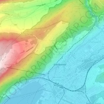
Name: Evilard topographic map, elevation, terrain.

Location: Evilard, Biel/Bienne administrative district, Seeland administrative region, Bern, Switzerland (47.13278 7.19084 47.15721 7.24944)

Average elevation: 1,913 ft

Minimum elevation: 1,391 ft

Maximum elevation: 3,071 ft

Other topographic maps

Click on a map to view its topography, its elevation and its terrain.

Gear up for your next adventure:

🗺️NatGeo Topo Maps - High-quality waterproof printed topographic maps of US Parks
🧥Men's Rain Shells - Premium waterproof and breathable jackets for mountain weather
🧦Merino Wool Socks - Moisture-wicking, blister-preventing socks for long treks
🪄Magnetic Compass - Accurate compass for navigation
📷Action Cameras - Rugged cameras to document your journeys across rugged terrain

As an Amazon Associate, this site earns from qualifying purchases at no extra cost to you.