
Staining topographic map
Interactive map
Click on the map to display elevation.
About this map
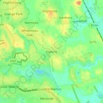
Name: Staining topographic map, elevation, terrain.
Average elevation: 46 ft
Minimum elevation: -7 ft
Maximum elevation: 95 ft
Other topographic maps
Click on a map to view its topography, its elevation and its terrain.
Lytham St Annes
United Kingdom > England > Lancashire > Borough of Fylde
Lytham St Annes, Borough of Fylde, Lancashire, England, FY8 4AR, United Kingdom
Average elevation: 16 ft
Warton Bank
United Kingdom > England > Lancashire > Borough of Fylde > Warton
Warton Bank, Bryning-with-Warton, Warton, Borough of Fylde, Lancashire, England, PR4 1TB, United Kingdom
Average elevation: 26 ft
Freckleton
United Kingdom > England > Lancashire > Borough of Fylde
Freckleton, Borough of Fylde, Lancashire, England, United Kingdom
Average elevation: 39 ft
Thistleton
United Kingdom > England > Lancashire > Borough of Fylde
Thistleton, Greenhalgh-with-Thistleton, Borough of Fylde, Lancashire, England, PR4 3XA, United Kingdom
Average elevation: 56 ft
Weeton
United Kingdom > England > Lancashire > Borough of Fylde
Weeton, Borough of Fylde, Lancashire, England, PR4 3PB, United Kingdom
Average elevation: 72 ft
Kirkham
United Kingdom > England > Lancashire > Borough of Fylde
Kirkham, Borough of Fylde, Lancashire, England, United Kingdom
Average elevation: 72 ft