Geolocate

Joppa topographic map

Click on the map to display elevation.

About this map

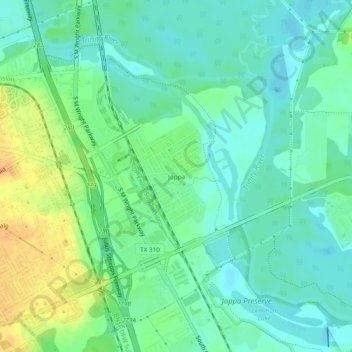
Name: Joppa topographic map, elevation, terrain.

Location: Joppa, Dallas, Dallas County, Texas, 75216, United States (32.69268 -96.76469 32.73268 -96.72469)

Average elevation: 413 ft

Minimum elevation: 374 ft

Maximum elevation: 486 ft

Dallas County trails, hiking, mountain biking, running and outdoor activities

Other topographic maps

Click on a map to view its topography, its elevation and its terrain.

Dealey Plaza

United States > Texas > Dallas County > Dallas

Average elevation: 433 ft

Klyde Warren Park

United States > Texas > Dallas County > Dallas

Average elevation: 466 ft

Pioneer Park

United States > Texas > Dallas County > Dallas

Average elevation: 443 ft

Gear up for your next adventure:

🦶Hiking Gaiters - Keep debris and water out of your boots
📚USA Hiking Guide Books - Top trail guides and map books
🩳Quick‑Dry Hiking Shorts - Comfortable and quick‑dry shorts for summer hiking
🗃️Trail First Aid Kit - Essential kit for outdoor injuries and emergencies
🪶Fire Starter Kit - Reliable fire starter for survival and camping

As an Amazon Associate, this site earns from qualifying purchases at no extra cost to you.