
Thank you for supporting this site ❤️
Make a donation
Make a donation
Gear up for your next adventure:
As an Amazon Associate, this site earns from qualifying purchases at no extra cost to you.
Saitama topographic map
Click on the map to display elevation.
Thank you for supporting this site ❤️
Make a donation
Make a donation
Gear up for your next adventure:
As an Amazon Associate, this site earns from qualifying purchases at no extra cost to you.
About this map
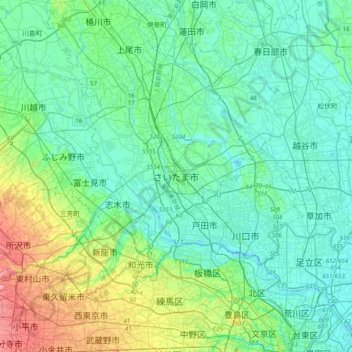
Name: Saitama topographic map, elevation, terrain.
Location: Saitama, さいたま市, Préfecture de Saitama, 3300061, Japon (35.70164 139.48580 36.02164 139.80580)
Average elevation: 69 ft
Minimum elevation: -13 ft
Maximum elevation: 335 ft
Thank you for supporting this site ❤️
Make a donation
Make a donation
Gear up for your next adventure:
As an Amazon Associate, this site earns from qualifying purchases at no extra cost to you.