Geolocate

Singao topographic map

Click on the map to display elevation.

About this map

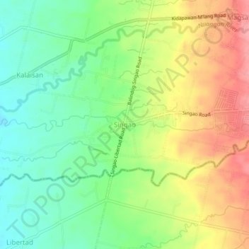
Name: Singao topographic map, elevation, terrain.

Location: Singao, Kidapawan, Cotabato, Soccsksargen, 9400, Philippines (6.97578 125.03339 7.01578 125.07339)

Average elevation: 548 ft

Minimum elevation: 404 ft

Maximum elevation: 728 ft

Other topographic maps

Click on a map to view its topography, its elevation and its terrain.

Matingao River

Philippines > Cotabato > Kidapawan > Balabag

Average elevation: 1,985 ft

Pulangi River

Philippines > Cotabato > Kidapawan

Average elevation: 1,444 ft

Gear up for your next adventure:

😴Insulated Sleeping Pads - Compact and warm pads for high-elevation camping
🛶Inflatable Kayak - Portable kayak for rivers, lakes, and expeditions
🕶️Glacier Sunglasses - Side shields to protect eyes from high-altitude snow glare
🖼️Topo Map Wall Art - Decorative topographic prints of famous peaks and regions
🏔️Mountain Trail Maps - High‑detail maps for popular peaks

As an Amazon Associate, this site earns from qualifying purchases at no extra cost to you.