
Make a donation
Gear up for your next adventure:
As an Amazon Associate, this site earns from qualifying purchases at no extra cost to you.
Seife topographic map
Click on the map to display elevation.
Make a donation
Gear up for your next adventure:
As an Amazon Associate, this site earns from qualifying purchases at no extra cost to you.
About this map
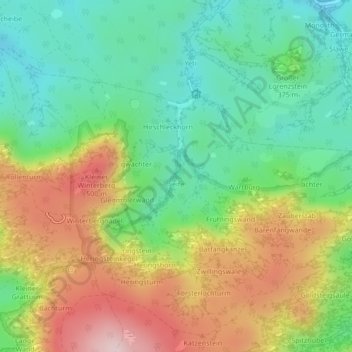
Name: Seife topographic map, elevation, terrain.
Average elevation: 1,129 ft
Minimum elevation: 712 ft
Maximum elevation: 1,762 ft
Make a donation
Gear up for your next adventure:
As an Amazon Associate, this site earns from qualifying purchases at no extra cost to you.
Other topographic maps
Click on a map to view its topography, its elevation and its terrain.
Porschdorf
Deutschland > Sachsen > Sächsische Schweiz-Osterzgebirge > Bad Schandau
Das Quellreihendorf (Waldhufendorf) befindet sich an der Vereinigung von Polenz und Sebnitz zum Lachsbach kurz vor dessen Mündung in die Elbe und der Ort liegt auf 130 m ü. NN. Zur Gemarkung gehört auch der bekannte Lilienstein, eines der imposantesten Felsgebilde des Elbsandsteingebirges. Auf der unterhalb…
Average elevation: 755 ft