Geolocate

Shell Knob topographic map

Click on the map to display elevation.

About this map

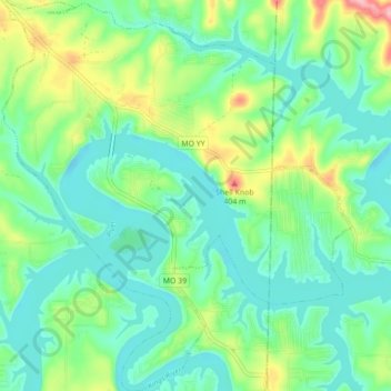
Name: Shell Knob topographic map, elevation, terrain.

Location: Shell Knob, Barry County, Missouri, United States (36.57032 -93.64132 36.64041 -93.56318)

Average elevation: 1,004 ft

Minimum elevation: 879 ft

Maximum elevation: 1,332 ft

Barry County trails, hiking, mountain biking, running and outdoor activities

Other topographic maps

Click on a map to view its topography, its elevation and its terrain.

Eagle Rock

United States > Missouri > Barry County

Average elevation: 1,056 ft

McDowell

United States > Missouri > Barry County

Average elevation: 1,263 ft

Eagle Rock

United States > Missouri > Barry County

Average elevation: 1,056 ft

Gear up for your next adventure:

🔌Solar Panel Charger - Charge gear sustainably outdoors
🧥Waterproof Jacket for Hiking - Breathable and rugged rain jacket for outdoor excursions
🔪Outdoor Multitools - Essential survival tools for gear repair and field use
🩳Quick‑Dry Hiking Shorts - Comfortable and quick‑dry shorts for summer hiking
📦Gear Storage Bags - Organize and protect outdoor equipment

As an Amazon Associate, this site earns from qualifying purchases at no extra cost to you.