
Make a donation
Gear up for your next adventure:
As an Amazon Associate, this site earns from qualifying purchases at no extra cost to you.
Eagle Rock topographic map
Click on the map to display elevation.
Make a donation
Gear up for your next adventure:
As an Amazon Associate, this site earns from qualifying purchases at no extra cost to you.
About this map
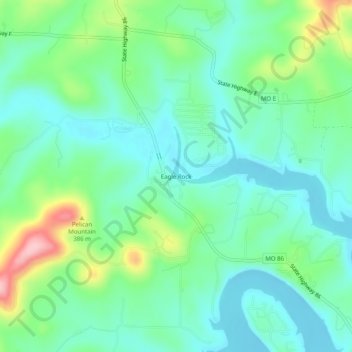
Name: Eagle Rock topographic map, elevation, terrain.
Location: Eagle Rock, Barry County, Missouri, 65641, United States (36.52812 -93.77436 36.56812 -93.73436)
Average elevation: 1,056 ft
Minimum elevation: 906 ft
Maximum elevation: 1,460 ft
Barry County trails, hiking, mountain biking, running and outdoor activities
Make a donation
Gear up for your next adventure:
As an Amazon Associate, this site earns from qualifying purchases at no extra cost to you.
Other topographic maps
Click on a map to view its topography, its elevation and its terrain.
Make a donation
Gear up for your next adventure:
As an Amazon Associate, this site earns from qualifying purchases at no extra cost to you.
Purdy
United States > Missouri > Barry County
US Department of the Interior Original Surveys and USGS Topographical map showing the Butterfield Overland Mail Route
Average elevation: 1,460 ft
Purdy
United States > Missouri > Barry County
US Department of the Interior Original Surveys and USGS Topographical map showing the Butterfield Overland Mail Route
Average elevation: 1,460 ft
Make a donation
Gear up for your next adventure:
As an Amazon Associate, this site earns from qualifying purchases at no extra cost to you.