
Make a donation
Gear up for your next adventure:
As an Amazon Associate, this site earns from qualifying purchases at no extra cost to you.
Westheim topographic map
Click on the map to display elevation.
Make a donation
Gear up for your next adventure:
As an Amazon Associate, this site earns from qualifying purchases at no extra cost to you.
About this map
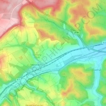
Name: Westheim topographic map, elevation, terrain.
Average elevation: 984 ft
Minimum elevation: 679 ft
Maximum elevation: 1,450 ft
Make a donation
Gear up for your next adventure:
As an Amazon Associate, this site earns from qualifying purchases at no extra cost to you.
Other topographic maps
Click on a map to view its topography, its elevation and its terrain.
Beringhausen
Deutschland > Nordrhein-Westfalen > Hochsauerlandkreis > Marsberg
Average elevation: 1,237 ft
Bredelar
Deutschland > Nordrhein-Westfalen > Hochsauerlandkreis > Marsberg
Average elevation: 1,171 ft
Tieberg
Deutschland > Nordrhein-Westfalen > Hochsauerlandkreis > Marsberg > Oesdorf
Average elevation: 1,270 ft
Make a donation
Gear up for your next adventure:
As an Amazon Associate, this site earns from qualifying purchases at no extra cost to you.
Mäuseturm (Donnersberger Warte)
Deutschland > Nordrhein-Westfalen > Hochsauerlandkreis > Marsberg
Average elevation: 1,207 ft
Auf der Wiemecke
Deutschland > Nordrhein-Westfalen > Hochsauerlandkreis > Marsberg
Das Grünland wird extensiv mit Rindern beweidet. Im NSG beweidet u. a. der Verein für Natur- und Vogelschutz im Hochsauerlandkreis mit Rotem Höhenvieh Flächen die der Verein ankaufte.
Average elevation: 1,089 ft