
Make a donation
Gear up for your next adventure:
As an Amazon Associate, this site earns from qualifying purchases at no extra cost to you.
Mérida topographic map
Click on the map to display elevation.
Make a donation
Gear up for your next adventure:
As an Amazon Associate, this site earns from qualifying purchases at no extra cost to you.
Mérida
Mérida is located in the northwest part of the state of Yucatán, which occupies the northern portion of the Yucatán Peninsula. To the east is the state of Quintana Roo, to the west is the state of Campeche, to the north is the Gulf of Mexico, and far to the south is the state of Chiapas. The city is also located in the Chicxulub Crater. It has a very flat topography and is only 9 metres (30 ft) above sea level. The land outside of Mérida is covered with smaller scrub trees and former henequen fields. Almost no surface water exists, but several cenotes (underground springs and rivers) are found across the state. Mérida has a centro histórico typical of colonial Spanish cities. The street grid is based on odd-numbered streets running east/west and even-numbered streets running north–south, with Calles 60 and 61 bounding the "Plaza Grande" in the heart of the city. The more affluent neighborhoods are located to the north and the most densely populated areas are to the south. The Centro Histórico area is becoming increasingly popular with Americans and other expatriates who are rescuing and restoring the classic colonial structures. In 2007 the Los Angeles Times recently noted this surge of interest in rescuing Mérida's historic downtown.
Make a donation
Gear up for your next adventure:
As an Amazon Associate, this site earns from qualifying purchases at no extra cost to you.
About this map
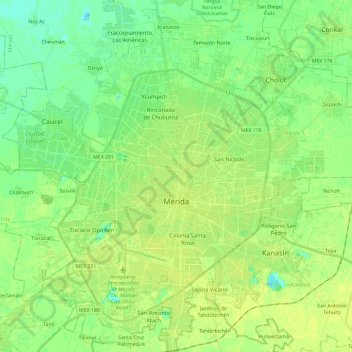
Name: Mérida topographic map, elevation, terrain.
Location: Mérida, Yucatán, Mexico (20.87088 -89.73035 21.08545 -89.52476)
Average elevation: 30 ft
Minimum elevation: 3 ft
Maximum elevation: 49 ft
Make a donation
Gear up for your next adventure:
As an Amazon Associate, this site earns from qualifying purchases at no extra cost to you.
Other topographic maps
Click on a map to view its topography, its elevation and its terrain.
Make a donation
Gear up for your next adventure:
As an Amazon Associate, this site earns from qualifying purchases at no extra cost to you.
Make a donation
Gear up for your next adventure:
As an Amazon Associate, this site earns from qualifying purchases at no extra cost to you.
Estación de Campo Rio Lagartos de la Reserva de la Biosfera Ria Lagartos
Mexico > Yucatán > Río Lagartos
Average elevation: 13 ft
Make a donation
Gear up for your next adventure:
As an Amazon Associate, this site earns from qualifying purchases at no extra cost to you.
Make a donation
Gear up for your next adventure:
As an Amazon Associate, this site earns from qualifying purchases at no extra cost to you.