
Make a donation
Gear up for your next adventure:
As an Amazon Associate, this site earns from qualifying purchases at no extra cost to you.
Ebernburg topographic map
Click on the map to display elevation.
Make a donation
Gear up for your next adventure:
As an Amazon Associate, this site earns from qualifying purchases at no extra cost to you.
Ebernburg
Die Ebernburg steht am südöstlichen Gemarkungsrand des gleichnamigen Stadtteils auf einem Bergsporn oberhalb des Nahetals in einer Höhe von 185 m ü. NHN.
Make a donation
Gear up for your next adventure:
As an Amazon Associate, this site earns from qualifying purchases at no extra cost to you.
About this map
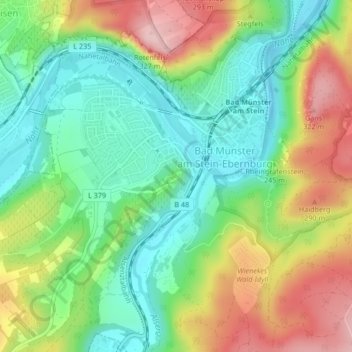
Name: Ebernburg topographic map, elevation, terrain.
Average elevation: 620 ft
Minimum elevation: 341 ft
Maximum elevation: 1,053 ft
Make a donation
Gear up for your next adventure:
As an Amazon Associate, this site earns from qualifying purchases at no extra cost to you.
Other topographic maps
Click on a map to view its topography, its elevation and its terrain.
Bad Münster am Stein-Ebernburg
Deutschland > Rheinland-Pfalz > Landkreis Bad Kreuznach > Bad Kreuznach
Average elevation: 722 ft
55545
Deutschland > Rheinland-Pfalz > Landkreis Bad Kreuznach > Bad Kreuznach
Average elevation: 558 ft