Geolocate

Chillum topographic map

Click on the map to display elevation.

About this map

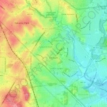
Name: Chillum topographic map, elevation, terrain.

Location: Chillum, Prince George's County, Maryland, United States (38.94383 -77.00250 38.98692 -76.95394)

Average elevation: 141 ft

Minimum elevation: 20 ft

Maximum elevation: 341 ft

Prince George's County trails, hiking, mountain biking, running and outdoor activities

Gear up for your next adventure:

🎒Waterproof Dry Bags - Keep your electronics and maps dry inside your pack
🔥Plasma Lighters - Windproof lighters that work in any weather condition
🧣Hiking Neck Gaiter - Multi‑use neck protection for outdoor weather
🌐World Map Poster - Decorative world maps with topographic info
🍳Camping Cook Set - Complete cookware for outdoor meals

As an Amazon Associate, this site earns from qualifying purchases at no extra cost to you.