
Make a donation
Gear up for your next adventure:
As an Amazon Associate, this site earns from qualifying purchases at no extra cost to you.
Pic de Troumouse topographic map
Click on the map to display elevation.
Make a donation
Gear up for your next adventure:
As an Amazon Associate, this site earns from qualifying purchases at no extra cost to you.
About this map
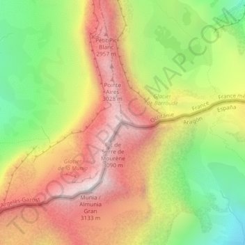
Name: Pic de Troumouse topographic map, elevation, terrain.
Location: Pic de Troumouse, Sobrarbe, Huesca, Aragon, Espagne (42.72240 0.13669 42.72250 0.13679)
Average elevation: 8,274 ft
Minimum elevation: 6,175 ft
Maximum elevation: 10,220 ft
Make a donation
Gear up for your next adventure:
As an Amazon Associate, this site earns from qualifying purchases at no extra cost to you.
Other topographic maps
Click on a map to view its topography, its elevation and its terrain.
Make a donation
Gear up for your next adventure:
As an Amazon Associate, this site earns from qualifying purchases at no extra cost to you.
Boltaña
Un peu plus loin, sur un promontoire, au dos de Margudgued, et au sud de Boltaña, est situé Sieste, à 730 mètres d’altitude, et a 28 habitants. Ces vues panoramiques sont remarquables. On aperçoit la Vallée de l’Ara qui s’étend jusqu’à Ainsa, au fond et à l’est; au nord, le Massif du Mont…
Average elevation: 2,822 ft