
Make a donation
Gear up for your next adventure:
As an Amazon Associate, this site earns from qualifying purchases at no extra cost to you.
Waterloos topographic map
Click on the map to display elevation.
Make a donation
Gear up for your next adventure:
As an Amazon Associate, this site earns from qualifying purchases at no extra cost to you.
Waterloos
Het gehucht ligt op het overgangsgebied van de Vlakte van Bocholt en het Kempens Plateau op een hoogte van ongeveer 50 meter. Direct ten westen van Waterloos is er een steilrand naar het plateau dat gelegen is op een hoogte van zo'n 70 meter.
Make a donation
Gear up for your next adventure:
As an Amazon Associate, this site earns from qualifying purchases at no extra cost to you.
About this map
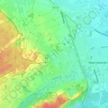
Name: Waterloos topographic map, elevation, terrain.
Location: Waterloos, Neeroeteren, Maaseik, Limburg, 3680, België (51.07177 5.65925 51.11177 5.69925)
Average elevation: 157 ft
Minimum elevation: 102 ft
Maximum elevation: 269 ft
Make a donation
Gear up for your next adventure:
As an Amazon Associate, this site earns from qualifying purchases at no extra cost to you.