
Make a donation
Gear up for your next adventure:
As an Amazon Associate, this site earns from qualifying purchases at no extra cost to you.
Quadra Island topographic map
Click on the map to display elevation.
Make a donation
Gear up for your next adventure:
As an Amazon Associate, this site earns from qualifying purchases at no extra cost to you.
About this map
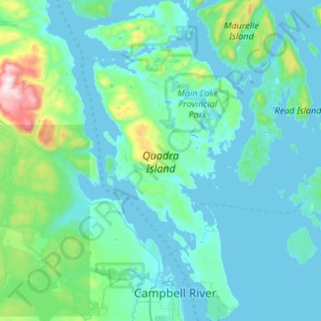
Name: Quadra Island topographic map, elevation, terrain.
Average elevation: 420 ft
Minimum elevation: -7 ft
Maximum elevation: 3,980 ft
Make a donation
Gear up for your next adventure:
As an Amazon Associate, this site earns from qualifying purchases at no extra cost to you.
Other topographic maps
Click on a map to view its topography, its elevation and its terrain.
Quathiaski Cove
Canada > British Columbia > Strathcona Regional District > Area B (Discovery Islands/Mainland Inlets)
Average elevation: 131 ft
Broken Islands
Canada > British Columbia > Strathcona Regional District > Area B (Discovery Islands/Mainland Inlets)
Average elevation: 33 ft
Mount Bute
Canada > British Columbia > Strathcona Regional District > Area B (Discovery Islands/Mainland Inlets)
Average elevation: 6,539 ft
Mount Hayes
Canada > British Columbia > Strathcona Regional District > Area B (Discovery Islands/Mainland Inlets)
Average elevation: 3,612 ft
Make a donation
Gear up for your next adventure:
As an Amazon Associate, this site earns from qualifying purchases at no extra cost to you.
Heriot Bay
Canada > British Columbia > Strathcona Regional District > Area B (Discovery Islands/Mainland Inlets)
Average elevation: 125 ft
Mount Raleigh
Canada > British Columbia > Strathcona Regional District > Area B (Discovery Islands/Mainland Inlets)
Mount Raleigh, elevation 3,132 m (10,276 ft), is one of the principal summits of the Pacific Ranges of the Coast Mountains of southern British Columbia in Canada. It is located just southeast of the confluence of the Southgate and Bishop Rivers, northeast of the head of Bute Inlet, and is the highest summit…
Average elevation: 7,920 ft
Discovery Mountain
Canada > British Columbia > Strathcona Regional District > Area B (Discovery Islands/Mainland Inlets)
Average elevation: 1,184 ft
Ripple Rock
Canada > British Columbia > Strathcona Regional District > Area B (Discovery Islands/Mainland Inlets)
Average elevation: 131 ft
Make a donation
Gear up for your next adventure:
As an Amazon Associate, this site earns from qualifying purchases at no extra cost to you.
Pembroke Range
Canada > British Columbia > Strathcona Regional District > Area B (Discovery Islands/Mainland Inlets)
Average elevation: 2,077 ft