Geolocate

Arona topographic map

Click on the map to display elevation.

About this map

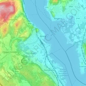
Name: Arona topographic map, elevation, terrain.

Location: Arona, Novara, Piedmont, Italy (45.72521 8.49664 45.78496 8.57964)

Average elevation: 817 ft

Minimum elevation: 623 ft

Maximum elevation: 1,696 ft

Other topographic maps

Click on a map to view its topography, its elevation and its terrain.

Agrate

Italy > Piedmont > Novara

Average elevation: 1,063 ft

Pisogno

Italy > Piedmont > Novara > Miasino

Average elevation: 1,729 ft

Gaggiolo

Italy > Piedmont > Novara

Average elevation: 692 ft

Gear up for your next adventure:

🍳Camping Cook Set - Complete cookware for outdoor meals
🚁Photography Drones - Capture stunning aerial views of landforms and topography
🛏️Cold Weather Sleeping Bag - Warm sleeping bag for cold conditions
📦Dry Bags Set - Waterproof storage for electronics and clothes
Solar GPS Watches - Advanced multisport watches with built-in topographic maps

As an Amazon Associate, this site earns from qualifying purchases at no extra cost to you.