
Make a donation
Gear up for your next adventure:
As an Amazon Associate, this site earns from qualifying purchases at no extra cost to you.
Mettmenstetten topographic map
Click on the map to display elevation.
Make a donation
Gear up for your next adventure:
As an Amazon Associate, this site earns from qualifying purchases at no extra cost to you.
Mettmenstetten
The municipality includes the village of Mettmenstetten, with the two core sections of Ober- and Untermettmenstetten as well as the other sections; Dachlissen, Eigi, Grossholz, Herferswil, Hübscheren, Rossau and Wissenbach. It is located an elevation of 460 m (1,510 ft).
Make a donation
Gear up for your next adventure:
As an Amazon Associate, this site earns from qualifying purchases at no extra cost to you.
About this map
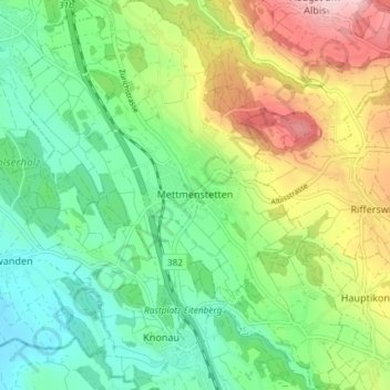
Name: Mettmenstetten topographic map, elevation, terrain.
Location: Mettmenstetten, Bezirk Affoltern, Zurich, 8932, Switzerland (47.21838 8.43208 47.26832 8.50067)
Average elevation: 1,660 ft
Minimum elevation: 1,276 ft
Maximum elevation: 2,385 ft
Make a donation
Gear up for your next adventure:
As an Amazon Associate, this site earns from qualifying purchases at no extra cost to you.
Other topographic maps
Click on a map to view its topography, its elevation and its terrain.