
Make a donation
Gear up for your next adventure:
As an Amazon Associate, this site earns from qualifying purchases at no extra cost to you.
Chicacao topographic map
Click on the map to display elevation.
Make a donation
Gear up for your next adventure:
As an Amazon Associate, this site earns from qualifying purchases at no extra cost to you.
About this map
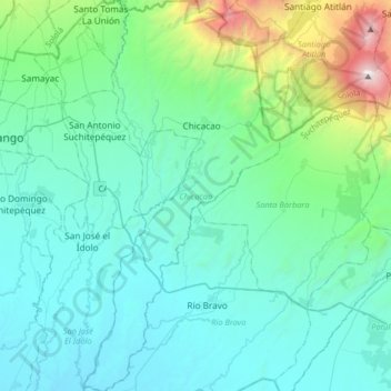
Name: Chicacao topographic map, elevation, terrain.
Location: Chicacao, Suchitepéquez, Guatemala (14.32781 -91.42503 14.64349 -91.26160)
Average elevation: 1,903 ft
Minimum elevation: 171 ft
Maximum elevation: 11,565 ft
Make a donation
Gear up for your next adventure:
As an Amazon Associate, this site earns from qualifying purchases at no extra cost to you.
Other topographic maps
Click on a map to view its topography, its elevation and its terrain.
San Antonio Suchitepéquez
Guatemala > Suchitepéquez > San Antonio Suchitepéquez
Average elevation: 1,322 ft
Make a donation
Gear up for your next adventure:
As an Amazon Associate, this site earns from qualifying purchases at no extra cost to you.