Geolocate

Edmond topographic map

Click on the map to display elevation.

About this map

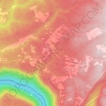
Name: Edmond topographic map, elevation, terrain.

Location: Edmond, Fayette County, West Virginia, 25837, United States (38.04233 -81.04732 38.08233 -81.00732)

Average elevation: 1,955 ft

Minimum elevation: 873 ft

Maximum elevation: 2,362 ft

Fayette County trails, hiking, mountain biking, running and outdoor activities

Other topographic maps

Click on a map to view its topography, its elevation and its terrain.

Ansted

United States > West Virginia > Fayette County

Average elevation: 1,572 ft

Powellton

United States > West Virginia > Fayette County

Average elevation: 1,552 ft

Smithers

United States > West Virginia > Fayette County

Average elevation: 1,119 ft

Pax

United States > West Virginia > Fayette County

Average elevation: 1,821 ft

Montgomery

United States > West Virginia > Fayette County

Average elevation: 1,106 ft

Gear up for your next adventure:

📷Action Camera - Capture your outdoor adventures in HD
🩹Survival Bandages - High‑quality bandages for emergencies
🎒Outdoor Daypacks - Lightweight backpacks designed for carrying maps and essential gear
🧣Merino Neck Gaiters - Multi-functional headwear for wind and sun protection
🔥Plasma Lighters - Windproof lighters that work in any weather condition

As an Amazon Associate, this site earns from qualifying purchases at no extra cost to you.