
Pleasantside topographic map
Click on the map to display elevation.
About this map
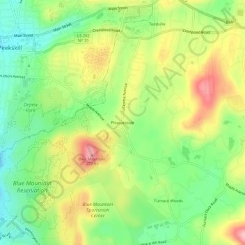
Name: Pleasantside topographic map, elevation, terrain.
Average elevation: 354 ft
Minimum elevation: 112 ft
Maximum elevation: 673 ft
Westchester County trails, hiking, mountain biking, running and outdoor activities
Other topographic maps
Click on a map to view its topography, its elevation and its terrain.
Verplanck
United States > New York > Westchester County > Town of Cortlandt > Verplanck
Average elevation: 36 ft
Village of Buchanan
United States > New York > Westchester County > Town of Cortlandt
Average elevation: 92 ft
Village of Buchanan
United States > New York > Westchester County > Town of Cortlandt
Average elevation: 92 ft
Montrose
United States > New York > Westchester County > Town of Cortlandt > Montrose
Average elevation: 49 ft