
Town of Mineral Point topographic map
Interactive map
Click on the map to display elevation.
About this map
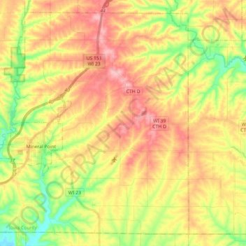
Name: Town of Mineral Point topographic map, elevation, terrain.
Average elevation: 1,099 ft
Minimum elevation: 850 ft
Maximum elevation: 1,332 ft
Iowa County trails, hiking, mountain biking, running and outdoor activities
Other topographic maps
Click on a map to view its topography, its elevation and its terrain.
Blue Mound State Park
United States > Wisconsin > Iowa County > Village of Blue Mounds
Average elevation: 1,365 ft
Tower Hill State Park
United States > Wisconsin > Iowa County > Town of Wyoming
Average elevation: 764 ft