
Make a donation
Gear up for your next adventure:
As an Amazon Associate, this site earns from qualifying purchases at no extra cost to you.
Gaborone topographic map
Click on the map to display elevation.
Make a donation
Gear up for your next adventure:
As an Amazon Associate, this site earns from qualifying purchases at no extra cost to you.
Gaborone
Gaborone is situated at 24°39′29″S 25°54′44″E / 24.65806°S 25.91222°E / -24.65806; 25.91222 between Kgale and Oodi Hills, on the Notwane River in the south-eastern corner of Botswana, and 15 kilometres (9.3 mi) from the South African border. The city lies at an elevation of 1,010 metres (3,310 ft) above sea level. Gaborone is surrounded by the following cities: Ramotswa to the southwest, Mogoditshane to the northwest, and Mochudi to the east, and Tlokweng across the river. Most of them are commuter towns for Gaborone. Suburbs in Gaborone include Broadhurst, Gaborone West, The Village, Naledi. Phakalane, an affluent suburb, lies about 13 km north of the city center.
Make a donation
Gear up for your next adventure:
As an Amazon Associate, this site earns from qualifying purchases at no extra cost to you.
About this map
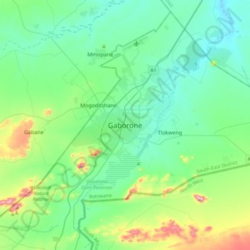
Name: Gaborone topographic map, elevation, terrain.
Location: Gaborone, South-East District, Botswana (-24.81814 25.74885 -24.49814 26.06885)
Average elevation: 3,386 ft
Minimum elevation: 3,104 ft
Maximum elevation: 4,475 ft
Make a donation
Gear up for your next adventure:
As an Amazon Associate, this site earns from qualifying purchases at no extra cost to you.
Other topographic maps
Click on a map to view its topography, its elevation and its terrain.