Geolocate

Fordham topographic map

Click on the map to display elevation.

About this map

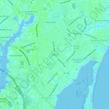
Name: Fordham topographic map, elevation, terrain.

Location: Fordham, Hampton, Virginia, 23663, United States (37.01765 -76.33411 37.05765 -76.29411)

Average elevation: 13 ft

Minimum elevation: -7 ft

Maximum elevation: 33 ft

Virginia trails, hiking, mountain biking, running and outdoor activities

Gear up for your next adventure:

🥘Titanium Cookware - Durable, featherlight pots and pans for backpacking
🔪Outdoor Multitools - Essential survival tools for gear repair and field use
🪶Survival Guide Book - Expert advice for emergency preparedness
🛰️Handheld GPS Units - Professional satellite navigators for precise backcountry mapping
🌎3D Topographic Globes - Raised relief globes for a tactile understanding of geography

As an Amazon Associate, this site earns from qualifying purchases at no extra cost to you.