Geolocate

Exmore topographic map

Click on the map to display elevation.

About this map

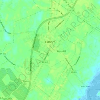
Name: Exmore topographic map, elevation, terrain.

Location: Exmore, Northampton County, Virginia, United States (37.51249 -75.85473 37.54588 -75.80876)

Average elevation: 26 ft

Minimum elevation: -20 ft

Maximum elevation: 39 ft

Northampton County trails, hiking, mountain biking, running and outdoor activities

Other topographic maps

Click on a map to view its topography, its elevation and its terrain.

Cheapside

United States > Virginia > Northampton County

Average elevation: 26 ft

Oyster

United States > Virginia > Northampton County

Average elevation: 13 ft

Gear up for your next adventure:

🥾Women's Hiking Boots - Top-rated trail boots with ankle support and superior grip
🪓Survival Multi‑Tool - Versatile tool for camp and trail tasks
📚USA Hiking Guide Books - Top trail guides and map books
🎒Waterproof Dry Bags - Keep your electronics and maps dry inside your pack
🧣Merino Neck Gaiters - Multi-functional headwear for wind and sun protection

As an Amazon Associate, this site earns from qualifying purchases at no extra cost to you.