
Make a donation
Gear up for your next adventure:
As an Amazon Associate, this site earns from qualifying purchases at no extra cost to you.
Vicenza topographic map
Click on the map to display elevation.
Make a donation
Gear up for your next adventure:
As an Amazon Associate, this site earns from qualifying purchases at no extra cost to you.
Vicenza
La città presenta una parte meridionale pianeggiante posta a una quota di 26 m s.l m. (zona di Borgo Casale), la parte del centro storico che si sviluppa tra i 33–40 m s.l.m., tra le anse dei principali fiumi Bacchiglione, Retrone e Astichello e infine una parte collinare (appartenente al sistema delle dorsali settentrionali dei Colli Berici) con un'altitudine massima di 183 m s.l.m. (corrispondente al Monte Bella Guardia).
Make a donation
Gear up for your next adventure:
As an Amazon Associate, this site earns from qualifying purchases at no extra cost to you.
About this map
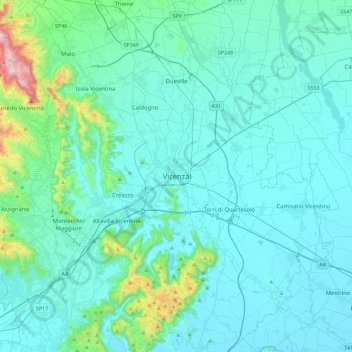
Name: Vicenza topographic map, elevation, terrain.
Location: Vicenza, Arcugnano, Vicenza, Veneto, 36100, Italia (45.38883 11.38788 45.70883 11.70788)
Average elevation: 302 ft
Minimum elevation: 43 ft
Maximum elevation: 2,516 ft
Make a donation
Gear up for your next adventure:
As an Amazon Associate, this site earns from qualifying purchases at no extra cost to you.
Other topographic maps
Click on a map to view its topography, its elevation and its terrain.
Parco Storico di Villa Guiccioli
Italia > Veneto > Vicenza > Vicenza > Campedello
Average elevation: 177 ft