
Make a donation
Gear up for your next adventure:
As an Amazon Associate, this site earns from qualifying purchases at no extra cost to you.
La Pila topographic map
Click on the map to display elevation.
Make a donation
Gear up for your next adventure:
As an Amazon Associate, this site earns from qualifying purchases at no extra cost to you.
About this map
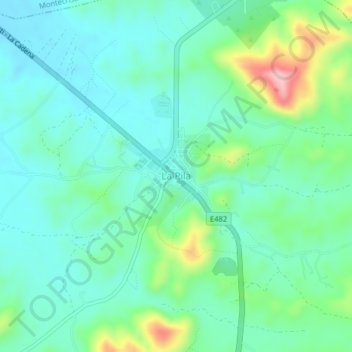
Name: La Pila topographic map, elevation, terrain.
Location: La Pila, Montecristi, Manabí, Ecuador (-1.12802 -80.60466 -1.08802 -80.56466)
Average elevation: 719 ft
Minimum elevation: 548 ft
Maximum elevation: 1,253 ft
Make a donation
Gear up for your next adventure:
As an Amazon Associate, this site earns from qualifying purchases at no extra cost to you.
Other topographic maps
Click on a map to view its topography, its elevation and its terrain.
Montecristi
Ecuador > Manabí > Montecristi
Montecristi es una ciudad ecuatoriana; cabecera cantonal del Cantón Montecristi, así como la quinta urbe más grande y poblada de la Provincia de Manabí. Se localiza al centro de la región litoral de Ecuador, en las faldas del cerro homónimo, a una altitud de 140 m s. n. m. y con un clima seco tropical de…
Average elevation: 472 ft
Montecristi
Ecuador > Manabí > Montecristi
Montecristi es una ciudad ecuatoriana; cabecera cantonal del Cantón Montecristi, así como la tercera urbe más grande y poblada de la Provincia de Manabí. Se localiza al centro de la región litoral de Ecuador, en las faldas del cerro homónimo, a una altitud de 140 m s. n. m. y con un clima seco tropical…
Average elevation: 472 ft