
Thank you for supporting this site ❤️
Make a donation
Make a donation
Gear up for your next adventure:
As an Amazon Associate, this site earns from qualifying purchases at no extra cost to you.
Kalruhi topographic map
Click on the map to display elevation.
Thank you for supporting this site ❤️
Make a donation
Make a donation
Gear up for your next adventure:
As an Amazon Associate, this site earns from qualifying purchases at no extra cost to you.
About this map
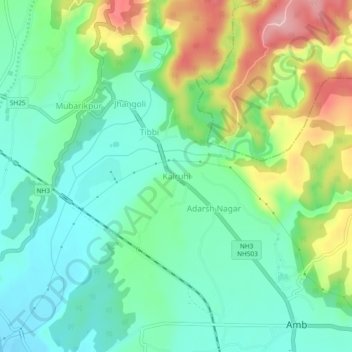
Name: Kalruhi topographic map, elevation, terrain.
Location: Kalruhi, Amb, Una, Himachal Pradesh, 177203, India (31.68208 76.08150 31.72208 76.12150)
Average elevation: 1,673 ft
Minimum elevation: 1,483 ft
Maximum elevation: 2,073 ft
Thank you for supporting this site ❤️
Make a donation
Make a donation
Gear up for your next adventure:
As an Amazon Associate, this site earns from qualifying purchases at no extra cost to you.