
Middlesex County topographic map
Click on the map to display elevation.
Middlesex County
The terrain trends from mostly level along the Connecticut River and Atlantic coast to gently rolling uplands away from them. The highest elevation is close to a triangulation station in Meshomasic State Forest, at 916 feet (279 m) above sea level; the lowest point is sea level.
About this map
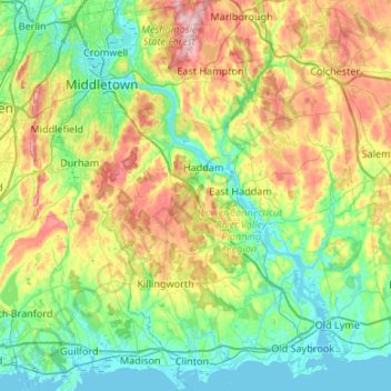
Name: Middlesex County topographic map, elevation, terrain.
Average elevation: 266 ft
Minimum elevation: -7 ft
Maximum elevation: 899 ft
Other topographic maps
Click on a map to view its topography, its elevation and its terrain.
Johnsonville
United States > Connecticut > Lower Connecticut River Valley Planning Region > East Haddam
Average elevation: 190 ft
Hamburg
United States > Connecticut > Lower Connecticut River Valley Planning Region > Lyme
Average elevation: 161 ft
Laysville
United States > Connecticut > Lower Connecticut River Valley Planning Region > Old Lyme
Average elevation: 108 ft
Fenwood
United States > Connecticut > Lower Connecticut River Valley Planning Region > Old Saybrook
Average elevation: 7 ft
Hadlyme
United States > Connecticut > Lower Connecticut River Valley Planning Region > Lyme
Average elevation: 148 ft
Mount Higby
United States > Connecticut > Lower Connecticut River Valley Planning Region > Middletown
Average elevation: 440 ft
Skinnerville
United States > Connecticut > Lower Connecticut River Valley Planning Region > East Hampton
Average elevation: 430 ft
Brockway
United States > Connecticut > Lower Connecticut River Valley Planning Region > Lyme
Average elevation: 154 ft
Knollwood
United States > Connecticut > Lower Connecticut River Valley Planning Region > Old Saybrook
Average elevation: 7 ft
Durham Center
United States > Connecticut > Lower Connecticut River Valley Planning Region > Durham
Average elevation: 256 ft
Otter Cove Estates
United States > Connecticut > Lower Connecticut River Valley Planning Region > Old Saybrook
Average elevation: 46 ft
North Lyme
United States > Connecticut > Lower Connecticut River Valley Planning Region > Lyme
Average elevation: 210 ft
Seven Falls
United States > Connecticut > Lower Connecticut River Valley Planning Region > Middletown
Average elevation: 318 ft
Hurd State Park
United States > Connecticut > Lower Connecticut River Valley Planning Region > East Hampton
Average elevation: 249 ft
Johnsonville
United States > Connecticut > Lower Connecticut River Valley Planning Region > East Haddam
Average elevation: 190 ft
Bashan
United States > Connecticut > Lower Connecticut River Valley Planning Region > East Haddam
Average elevation: 374 ft
Brazos Quarry Pond
United States > Connecticut > Lower Connecticut River Valley Planning Region > Portland
Average elevation: 66 ft
Oxford Park
United States > Connecticut > Lower Connecticut River Valley Planning Region > Cromwell
Average elevation: 105 ft
Arnolds
United States > Connecticut > Lower Connecticut River Valley Planning Region > Haddam
Average elevation: 236 ft
Grove Beach
United States > Connecticut > Lower Connecticut River Valley Planning Region > Westbrook
Average elevation: 23 ft
Essex
United States > Connecticut > Lower Connecticut River Valley Planning Region
Average elevation: 148 ft
Knollwood
United States > Connecticut > Lower Connecticut River Valley Planning Region > Old Saybrook
Average elevation: 7 ft
Clinton Beach
United States > Connecticut > Lower Connecticut River Valley Planning Region > Clinton
Average elevation: 13 ft