
Thank you for supporting this site ❤️
Make a donation
Make a donation
Gear up for your next adventure:
As an Amazon Associate, this site earns from qualifying purchases at no extra cost to you.
Chenzhou topographic map
Click on the map to display elevation.
Thank you for supporting this site ❤️
Make a donation
Make a donation
Gear up for your next adventure:
As an Amazon Associate, this site earns from qualifying purchases at no extra cost to you.
About this map
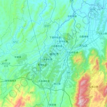
Name: Chenzhou topographic map, elevation, terrain.
Location: Chenzhou, Beihu District, Chenzhou, Hunan, 423000, China (25.61336 112.84943 25.93336 113.16943)
Average elevation: 1,194 ft
Minimum elevation: 394 ft
Maximum elevation: 5,249 ft
Thank you for supporting this site ❤️
Make a donation
Make a donation
Gear up for your next adventure:
As an Amazon Associate, this site earns from qualifying purchases at no extra cost to you.